


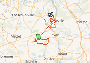
sentier test

Bruno Carlier
User

Length
48 km

Max alt
272 m

Uphill gradient
1452 m
Km-Effort
68 km

Min alt
77 m

Downhill gradient
1582 m
Boucle
No
Creation date :
2020-08-19 08:42:10.011
Updated on :
2020-09-06 10:17:14.664
12h26
Difficulty : Very easy

FREE GPS app for hiking
 SityTrail
IGN / Geographical institutes
SityTrail Plus
The world is yours!
About
Trail Walking of 48 km to be discovered at Wallonia, Namur, Anhée. This trail is proposed by Bruno Carlier.
Description
test 1
Photos


Positioning
Country:
Belgium
Region :
Wallonia
Department/Province :
Namur
Municipality :
Anhée
Location:
Denée
Start:(Dec)
Start:(UTM)
625716 ; 5573546 (31U) N.
Comments