


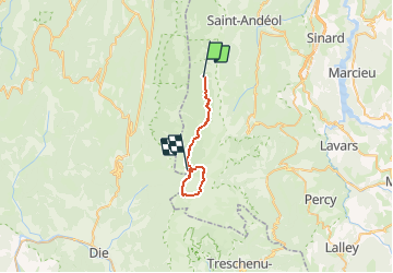
Jour2 Jasse du Play - Prépeyret
© OpenStreetMap contributors


7h00
Difficulty : Easy


Length
21 km
Max alt
1719 m
Uphill gradient
539 m
Km-Effort
28 km
Min alt
1559 m
Downhill gradient
552 m
Boucle
No
Creation date :
2014-12-10 00:00:00.0
Updated on :
2014-12-10 00:00:00.0
7h00
Difficulty : Easy
FREE GPS app for hiking
 SityTrail
IGN / Geographical institutes
SityTrail Plus
The world is yours!
About
Trail Winter sports of 21 km to be discovered at Auvergne-Rhône-Alpes, Isère, Gresse-en-Vercors. This trail is proposed by jerome-dupont@laposte.net.


Positioning
Country:
France
Region :
Auvergne-Rhône-Alpes
Department/Province :
Isère
Municipality :
Gresse-en-Vercors
Location:
Unknown
Start:(Dec)
Start:(UTM)
697516 ; 4976062 (31T) N.
Comments