


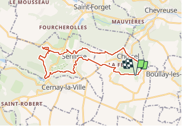
Breteuil - Moulin de Cernay

Glurps
User

Length
17.2 km

Max alt
182 m

Uphill gradient
344 m
Km-Effort
22 km

Min alt
95 m

Downhill gradient
343 m
Boucle
Yes
Creation date :
2020-09-06 09:16:48.0
Updated on :
2020-09-06 15:12:33.871
4h20
Difficulty : Medium

FREE GPS app for hiking
 SityTrail
IGN / Geographical institutes
SityTrail Plus
The world is yours!
About
Trail Walking of 17.2 km to be discovered at Ile-de-France, Yvelines, Choisel. This trail is proposed by Glurps.
Description
Château de breteuil moulin de cernay
Positioning
Country:
France
Region :
Ile-de-France
Department/Province :
Yvelines
Municipality :
Choisel
Location:
Unknown
Start:(Dec)
Start:(UTM)
428121 ; 5392151 (31U) N.
Comments