


Chantal le 06/09/20

clabidault
User

Length
15.6 km

Max alt
478 m

Uphill gradient
351 m
Km-Effort
20 km

Min alt
276 m

Downhill gradient
353 m
Boucle
Yes
Creation date :
2020-09-06 11:55:20.337
Updated on :
2020-09-06 17:02:42.134
3h08
Difficulty : Very easy

FREE GPS app for hiking
 SityTrail
IGN / Geographical institutes
SityTrail Plus
The world is yours!
About
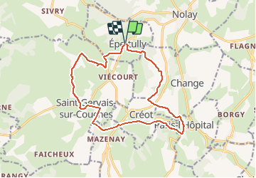
Trail Walking of 15.6 km to be discovered at Bourgogne-Franche-Comté, Saône-et-Loire, Épertully. This trail is proposed by clabidault.
Positioning
Country:
France
Region :
Bourgogne-Franche-Comté
Department/Province :
Saône-et-Loire
Municipality :
Épertully
Location:
Unknown
Start:(Dec)
Start:(UTM)
622129 ; 5199950 (31T) N.
Comments