


verneuil en halatte

Djaie60
User
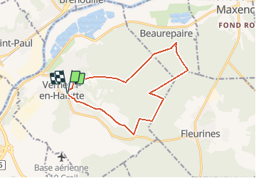

Length
12.7 km

Max alt
122 m

Uphill gradient
210 m
Km-Effort
15.5 km

Min alt
36 m

Downhill gradient
214 m
Boucle
Yes
Creation date :
2020-09-07 11:49:59.12
Updated on :
2020-09-07 12:07:17.172
3h21
Difficulty : Difficult

FREE GPS app for hiking
 SityTrail
IGN / Geographical institutes
SityTrail Plus
The world is yours!
About
Trail Walking of 12.7 km to be discovered at Hauts-de-France, Oise, Verneuil-en-Halatte. This trail is proposed by Djaie60.
Positioning
Country:
France
Region :
Hauts-de-France
Department/Province :
Oise
Municipality :
Verneuil-en-Halatte
Location:
Unknown
Start:(Dec)
Start:(UTM)
465226 ; 5457869 (31U) N.
Comments