


201007 Suarlee

guy284
User
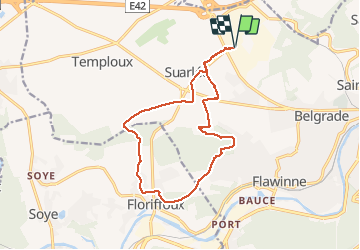

Length
13.6 km

Max alt
211 m

Uphill gradient
197 m
Km-Effort
16.3 km

Min alt
91 m

Downhill gradient
196 m
Boucle
Yes
Creation date :
2020-09-07 12:01:01.146
Updated on :
2020-09-08 00:11:01.493
2h42
Difficulty : Easy

FREE GPS app for hiking
 SityTrail
IGN / Geographical institutes
SityTrail Plus
The world is yours!
About
Trail Walking of 13.6 km to be discovered at Wallonia, Namur, Namur. This trail is proposed by guy284.
Positioning
Country:
Belgium
Region :
Wallonia
Department/Province :
Namur
Municipality :
Namur
Location:
Suarlée
Start:(Dec)
Start:(UTM)
627489 ; 5594197 (31U) N.
Comments