


Tracé_03-SEP-20 150818

rigol05
User
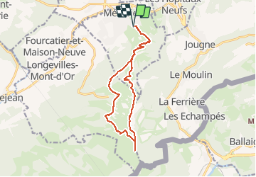

Length
14.2 km

Max alt
1450 m

Uphill gradient
634 m
Km-Effort
23 km

Min alt
1007 m

Downhill gradient
633 m
Boucle
Yes
Creation date :
2020-09-08 08:48:28.173
Updated on :
2020-09-08 09:04:49.832
--
Difficulty : Medium

FREE GPS app for hiking
 SityTrail
IGN / Geographical institutes
SityTrail Plus
The world is yours!
About
Trail On foot of 14.2 km to be discovered at Bourgogne-Franche-Comté, Doubs, Métabief. This trail is proposed by rigol05.
Description
Séjour Doubs sortie du 03/09/2020
Départ O.T. Métabief
Positioning
Country:
France
Region :
Bourgogne-Franche-Comté
Department/Province :
Doubs
Municipality :
Métabief
Location:
Unknown
Start:(Dec)
Start:(UTM)
298138 ; 5182865 (32T) N.
Comments