


alpage de fond d urle

raab
User
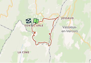

Length
13.5 km

Max alt
1640 m

Uphill gradient
477 m
Km-Effort
19.9 km

Min alt
1336 m

Downhill gradient
482 m
Boucle
Yes
Creation date :
2020-09-08 07:24:35.58
Updated on :
2020-09-08 13:27:49.27
6h01
Difficulty : Medium

FREE GPS app for hiking
 SityTrail
IGN / Geographical institutes
SityTrail Plus
The world is yours!
About
Trail Walking of 13.5 km to be discovered at Auvergne-Rhône-Alpes, Drôme, Bouvante. This trail is proposed by raab.
Positioning
Country:
France
Region :
Auvergne-Rhône-Alpes
Department/Province :
Drôme
Municipality :
Bouvante
Location:
Unknown
Start:(Dec)
Start:(UTM)
683187 ; 4974212 (31T) N.
Comments