


Metzeral et Sondernack

lemuid
User
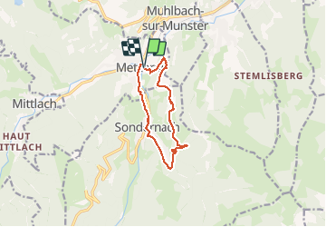

Length
9.9 km

Max alt
762 m

Uphill gradient
362 m
Km-Effort
14.7 km

Min alt
477 m

Downhill gradient
360 m
Boucle
Yes
Creation date :
2020-09-08 12:00:21.494
Updated on :
2020-09-22 07:43:36.039
3h01
Difficulty : Easy

FREE GPS app for hiking
 SityTrail
IGN / Geographical institutes
SityTrail Plus
The world is yours!
About
Trail Walking of 9.9 km to be discovered at Grand Est, Haut-Rhin, Metzeral. This trail is proposed by lemuid.
Positioning
Country:
France
Region :
Grand Est
Department/Province :
Haut-Rhin
Municipality :
Metzeral
Location:
Unknown
Start:(Dec)
Start:(UTM)
356295 ; 5319518 (32U) N.
Comments