


st jouvent thouron

pjoly
User
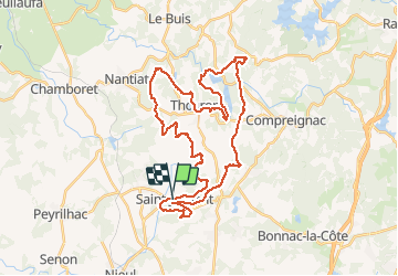

Length
39 km

Max alt
433 m

Uphill gradient
759 m
Km-Effort
49 km

Min alt
310 m

Downhill gradient
749 m
Boucle
Yes
Creation date :
2020-09-09 06:56:07.653
Updated on :
2020-09-09 10:40:24.239
3h44
Difficulty : Very easy

FREE GPS app for hiking
 SityTrail
IGN / Geographical institutes
SityTrail Plus
The world is yours!
About
Trail Mountain bike of 39 km to be discovered at New Aquitaine, Haute-Vienne, Saint-Jouvent. This trail is proposed by pjoly.
Positioning
Country:
France
Region :
New Aquitaine
Department/Province :
Haute-Vienne
Municipality :
Saint-Jouvent
Location:
Unknown
Start:(Dec)
Start:(UTM)
360832 ; 5090845 (31T) N.
Comments