


le col de l'alp

82240gerard
User
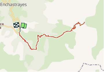

Length
11.9 km

Max alt
2488 m

Uphill gradient
843 m
Km-Effort
23 km

Min alt
1679 m

Downhill gradient
846 m
Boucle
Yes
Creation date :
2020-09-09 06:40:45.5
Updated on :
2020-09-09 13:43:32.587
7h01
Difficulty : Difficult

FREE GPS app for hiking
 SityTrail
IGN / Geographical institutes
SityTrail Plus
The world is yours!
About
Trail Walking of 11.9 km to be discovered at Provence-Alpes-Côte d'Azur, Alpes-de-Haute-Provence, Enchastrayes. This trail is proposed by 82240gerard.
Positioning
Country:
France
Region :
Provence-Alpes-Côte d'Azur
Department/Province :
Alpes-de-Haute-Provence
Municipality :
Enchastrayes
Location:
Unknown
Start:(Dec)
Start:(UTM)
316676 ; 4913884 (32T) N.
Comments