


2020-09-09_20h57m44_iti0370 (1)

jeanic63
User


--
Difficulty : Medium

FREE GPS app for hiking
 SityTrail
IGN / Geographical institutes
SityTrail Plus
The world is yours!
About
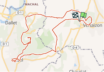
Trail On foot of 14.4 km to be discovered at Auvergne-Rhône-Alpes, Puy-de-Dôme, Vertaizon. This trail is proposed by jeanic63.
Description
Départ : du panneau de départ (Fontaine-lavoir), monter à gauche vers le village par la rue de la
Croix de Laire Basse puis chemin des Noyeraies. Emprunter successivement la rue de la Paix, la rue du
Marchidial, les escaliers et la rue de l'Ancienne Église. A la fourche, monter à gauche pour rejoindre le
sommet de la butte (Chapelle) et la table d'orientation (vue sur la Chaîne des puys et la Limagne). Traverser
le parc, et descendre par le chemin herbeux. Prendre à droite la rue de la Croix de Laire Haute sur 200
mètres et tourner à droite dans le premier chemin pour rejoindre la route (rue Chatel Vieux)
Positioning
Comments