Boucle du Val Joly par Clairfayts

BrassensJC
User
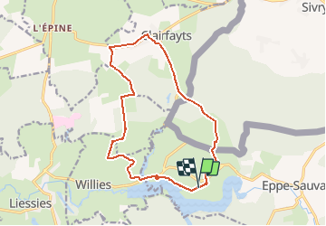

Length
14 km

Max alt
246 m

Uphill gradient
193 m
Km-Effort
16.6 km

Min alt
176 m

Downhill gradient
196 m
Boucle
Yes
Creation date :
2020-09-09 19:32:04.009
Updated on :
2020-09-09 19:33:46.938
3h37
Difficulty : Difficult

FREE GPS app for hiking
 SityTrail
IGN / Geographical institutes
SityTrail Plus
The world is yours!
About
Trail Walking of 14 km to be discovered at Hauts-de-France, Nord, Eppe-Sauvage. This trail is proposed by BrassensJC.
Positioning
Country:
France
Region :
Hauts-de-France
Department/Province :
Nord
Municipality :
Eppe-Sauvage
Location:
Unknown
Start:(Dec)
Start:(UTM)
581404 ; 5552578 (31U) N.
Comments