


Rochefort 2020

fra_depoorter
User
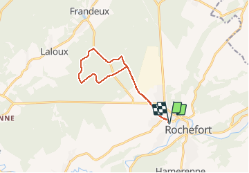

Length
10.9 km

Max alt
248 m

Uphill gradient
167 m
Km-Effort
13.1 km

Min alt
169 m

Downhill gradient
167 m
Boucle
Yes
Creation date :
2020-09-09 12:12:02.676
Updated on :
2020-09-10 07:42:30.094
2h25
Difficulty : Easy

FREE GPS app for hiking
 SityTrail
IGN / Geographical institutes
SityTrail Plus
The world is yours!
About
Trail Walking of 10.9 km to be discovered at Wallonia, Namur, Rochefort. This trail is proposed by fra_depoorter.
Description
Belle randonnée dans le bois de Behogne
Positioning
Country:
Belgium
Region :
Wallonia
Department/Province :
Namur
Municipality :
Rochefort
Location:
Rochefort
Start:(Dec)
Start:(UTM)
658148 ; 5558841 (31U) N.
Comments