


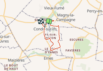
conde sur ifs

semaine
User

Length
9.2 km

Max alt
72 m

Uphill gradient
108 m
Km-Effort
10.6 km

Min alt
30 m

Downhill gradient
107 m
Boucle
Yes
Creation date :
2020-09-08 11:45:59.751
Updated on :
2020-09-10 08:26:14.33
2h35
Difficulty : Very easy

FREE GPS app for hiking
 SityTrail
IGN / Geographical institutes
SityTrail Plus
The world is yours!
About
Trail Walking of 9.2 km to be discovered at Normandy, Calvados, Condé-sur-Ifs. This trail is proposed by semaine.
Positioning
Country:
France
Region :
Normandy
Department/Province :
Calvados
Municipality :
Condé-sur-Ifs
Location:
Unknown
Start:(Dec)
Start:(UTM)
709862 ; 5436073 (30U) N.
Comments