


Maynal Beaufort page 129

grasgilbert
User
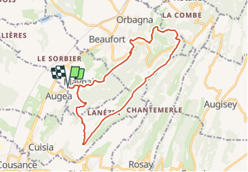

Length
16.2 km

Max alt
558 m

Uphill gradient
437 m
Km-Effort
22 km

Min alt
256 m

Downhill gradient
438 m
Boucle
Yes
Creation date :
2020-09-10 07:37:46.512
Updated on :
2021-08-05 14:53:12.401
5h30
Difficulty : Difficult

FREE GPS app for hiking
 SityTrail
IGN / Geographical institutes
SityTrail Plus
The world is yours!
About
Trail Walking of 16.2 km to be discovered at Bourgogne-Franche-Comté, Jura, Maynal. This trail is proposed by grasgilbert.
Description
refait totalement le circuit car impraticable à plusieurs endroits
ne pas faire à l'envers cause route goudronnée à la fin en descente
Positioning
Country:
France
Region :
Bourgogne-Franche-Comté
Department/Province :
Jura
Municipality :
Maynal
Location:
Unknown
Start:(Dec)
Start:(UTM)
685245 ; 5158864 (31T) N.
Comments