


La fontaine de Voire

gdela
User
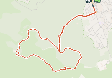

Length
7.4 km

Max alt
354 m

Uphill gradient
340 m
Km-Effort
12 km

Min alt
70 m

Downhill gradient
339 m
Boucle
Yes
Creation date :
2020-09-11 15:26:55.336
Updated on :
2020-09-11 15:30:54.669
--
Difficulty : Medium

FREE GPS app for hiking
 SityTrail
IGN / Geographical institutes
SityTrail Plus
The world is yours!
About
Trail On foot of 7.4 km to be discovered at Provence-Alpes-Côte d'Azur, Bouches-du-Rhône, Marseille. This trail is proposed by gdela.
Description
PR 10 arrêt La Cayole bus 23
moyen 3h00 7,5 km dénivelée 450 m
sentier escarpé avec passage rocheux
Positioning
Country:
France
Region :
Provence-Alpes-Côte d'Azur
Department/Province :
Bouches-du-Rhône
Municipality :
Marseille
Location:
9th Arrondissement
Start:(Dec)
Start:(UTM)
694867 ; 4789502 (31T) N.
Comments