


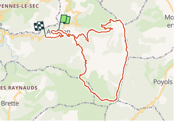
Aucelon

raygautier
User

Length
23 km

Max alt
1461 m

Uphill gradient
914 m
Km-Effort
35 km

Min alt
610 m

Downhill gradient
1028 m
Boucle
No
Creation date :
2020-09-12 07:06:40.0
Updated on :
2020-09-12 15:42:00.619
5h49
Difficulty : Unknown

FREE GPS app for hiking
 SityTrail
IGN / Geographical institutes
SityTrail Plus
The world is yours!
About
Trail Walking of 23 km to be discovered at Auvergne-Rhône-Alpes, Drôme, Aucelon. This trail is proposed by raygautier.
Positioning
Country:
France
Region :
Auvergne-Rhône-Alpes
Department/Province :
Drôme
Municipality :
Aucelon
Location:
Unknown
Start:(Dec)
Start:(UTM)
686094 ; 4943976 (31T) N.
Comments