


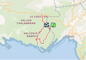
Calanque d'En Vau, Port Pin, Port Miou

gdela
User

Length
12.2 km

Max alt
260 m

Uphill gradient
436 m
Km-Effort
18 km

Min alt
41 m

Downhill gradient
435 m
Boucle
Yes
Creation date :
2020-09-12 19:54:32.008
Updated on :
2020-09-12 21:04:44.579
--
Difficulty : Medium

FREE GPS app for hiking
 SityTrail
IGN / Geographical institutes
SityTrail Plus
The world is yours!
About
Trail On foot of 12.2 km to be discovered at Provence-Alpes-Côte d'Azur, Bouches-du-Rhône, Marseille. This trail is proposed by gdela.
Description
PR 19, moyen 4h 12 km, denivelé 400m
montée raide , parcours rocheux avec éboulis
du point de vue, revenir au col de l'oule
arrêt Carpiane(citerne) bus Marseille Cassis


Positioning
Country:
France
Region :
Provence-Alpes-Côte d'Azur
Department/Province :
Bouches-du-Rhône
Municipality :
Marseille
Location:
9th Arrondissement
Start:(Dec)
Start:(UTM)
703971 ; 4788355 (31T) N.
Comments