


stavelot

annedogne
User
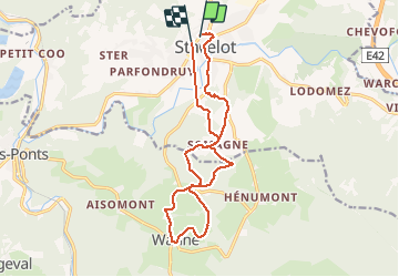

Length
13.9 km

Max alt
497 m

Uphill gradient
548 m
Km-Effort
21 km

Min alt
275 m

Downhill gradient
537 m
Boucle
Yes
Creation date :
2020-09-13 05:35:36.037
Updated on :
2020-09-13 09:07:31.792
3h31
Difficulty : Very easy

FREE GPS app for hiking
 SityTrail
IGN / Geographical institutes
SityTrail Plus
The world is yours!
About
Trail Nordic walking of 13.9 km to be discovered at Wallonia, Liège, Stavelot. This trail is proposed by annedogne.
Positioning
Country:
Belgium
Region :
Wallonia
Department/Province :
Liège
Municipality :
Stavelot
Location:
Stavelot
Start:(Dec)
Start:(UTM)
708168 ; 5586775 (31U) N.
Comments