


Nolay -Mont Julliard_13-09-2020

Kargil
User GUIDE
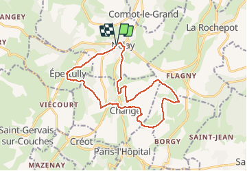

Length
16 km

Max alt
459 m

Uphill gradient
369 m
Km-Effort
21 km

Min alt
287 m

Downhill gradient
370 m
Boucle
Yes
Creation date :
2020-09-13 08:10:38.502
Updated on :
2020-09-13 19:18:05.681
4h07
Difficulty : Medium

FREE GPS app for hiking
 SityTrail
IGN / Geographical institutes
SityTrail Plus
The world is yours!
About
Trail Walking of 16 km to be discovered at Bourgogne-Franche-Comté, Côte-d'Or, Nolay. This trail is proposed by Kargil.
Positioning
Country:
France
Region :
Bourgogne-Franche-Comté
Department/Province :
Côte-d'Or
Municipality :
Nolay
Location:
Unknown
Start:(Dec)
Start:(UTM)
624061 ; 5201061 (31T) N.
Comments