


Cires lès Mello 12.6km

Djaie60
User
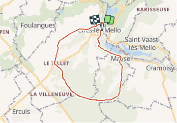

Length
12.7 km

Max alt
151 m

Uphill gradient
167 m
Km-Effort
14.9 km

Min alt
35 m

Downhill gradient
167 m
Boucle
Yes
Creation date :
2020-09-14 11:58:56.0
Updated on :
2021-01-20 15:38:16.751
--
Difficulty : Very easy

FREE GPS app for hiking
 SityTrail
IGN / Geographical institutes
SityTrail Plus
The world is yours!
About
Trail On foot of 12.7 km to be discovered at Hauts-de-France, Oise, Cires-lès-Mello. This trail is proposed by Djaie60.
Positioning
Country:
France
Region :
Hauts-de-France
Department/Province :
Oise
Municipality :
Cires-lès-Mello
Location:
Unknown
Start:(Dec)
Start:(UTM)
453516 ; 5457963 (31U) N.
Comments