


bouillonville

randolea
User
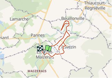

Length
13.1 km

Max alt
251 m

Uphill gradient
172 m
Km-Effort
15.3 km

Min alt
207 m

Downhill gradient
171 m
Boucle
Yes
Creation date :
2020-09-14 12:56:32.827
Updated on :
2020-09-14 14:11:00.802
1h06
Difficulty : Very easy

FREE GPS app for hiking
 SityTrail
IGN / Geographical institutes
SityTrail Plus
The world is yours!
About
Trail Mountain bike of 13.1 km to be discovered at Grand Est, Meurthe-et-Moselle, Essey-et-Maizerais. This trail is proposed by randolea.
Positioning
Country:
France
Region :
Grand Est
Department/Province :
Meurthe-et-Moselle
Municipality :
Essey-et-Maizerais
Location:
Unknown
Start:(Dec)
Start:(UTM)
705944 ; 5422179 (31U) N.
Comments