


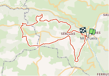
Meyrueis en boucle 23 km par Causse Noir

trekkingpassion
User

Length
23 km

Max alt
1047 m

Uphill gradient
699 m
Km-Effort
32 km

Min alt
701 m

Downhill gradient
700 m
Boucle
Yes
Creation date :
2020-09-14 07:19:06.052
Updated on :
2020-10-03 21:37:17.084
6h07
Difficulty : Medium

FREE GPS app for hiking
 SityTrail
IGN / Geographical institutes
SityTrail Plus
The world is yours!
About
Trail Walking of 23 km to be discovered at Occitania, Lozère, Meyrueis. This trail is proposed by trekkingpassion.
Description
Belle randonnée en boucle depuis le centre de Meyrueis en montant sur le causse Noir. Passage par la grotte surplombant les gorges de la Jonte.
Positioning
Country:
France
Region :
Occitania
Department/Province :
Lozère
Municipality :
Meyrueis
Location:
Unknown
Start:(Dec)
Start:(UTM)
534373 ; 4891655 (31T) N.
Comments