


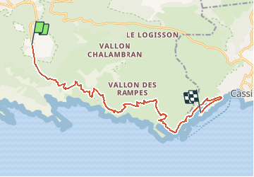
la traversee de Luminy / Cassis

gdela
User

Length
14.9 km

Max alt
428 m

Uphill gradient
622 m
Km-Effort
24 km

Min alt
8 m

Downhill gradient
733 m
Boucle
No
Creation date :
2020-09-14 15:31:35.959
Updated on :
2020-10-01 09:01:23.97
--
Difficulty : Medium

FREE GPS app for hiking
 SityTrail
IGN / Geographical institutes
SityTrail Plus
The world is yours!
About
Trail On foot of 14.9 km to be discovered at Provence-Alpes-Côte d'Azur, Bouches-du-Rhône, Marseille. This trail is proposed by gdela.
Description
PR 27 moyen, 5h30, 15 km denivelée 700m
difficulté sentiers escarpés et passage rocheux
terminus de la navette (car) Cassis presqu'il de Port-Miou
ou à l'arrivée Luminy terminus du bus 21
Positioning
Country:
France
Region :
Provence-Alpes-Côte d'Azur
Department/Province :
Bouches-du-Rhône
Municipality :
Marseille
Location:
9th Arrondissement
Start:(Dec)
Start:(UTM)
697860 ; 4789407 (31T) N.
Comments