


Magny en vexin

avdem
User

Length
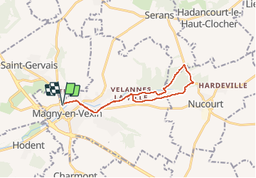
12.1 km

Max alt
129 m

Uphill gradient
129 m
Km-Effort
13.8 km

Min alt
67 m

Downhill gradient
130 m
Boucle
Yes
Creation date :
2020-09-17 07:58:00.301
Updated on :
2020-09-23 15:35:46.346
2h49
Difficulty : Very easy

FREE GPS app for hiking
 SityTrail
IGN / Geographical institutes
SityTrail Plus
The world is yours!
About
Trail Walking of 12.1 km to be discovered at Ile-de-France, Val-d'Oise, Magny-en-Vexin. This trail is proposed by avdem.
Description
Visite su campus Jules Cesar
Photos


Positioning
Country:
France
Region :
Ile-de-France
Department/Province :
Val-d'Oise
Municipality :
Magny-en-Vexin
Location:
Unknown
Start:(Dec)
Start:(UTM)
411390 ; 5445728 (31U) N.
Comments