


Les sucettes

raygautier
User
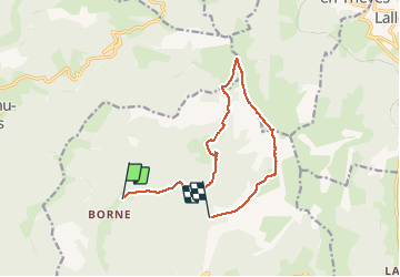

Length
12.4 km

Max alt
1764 m

Uphill gradient
875 m
Km-Effort
23 km

Min alt
926 m

Downhill gradient
496 m
Boucle
No
Creation date :
2020-09-17 08:04:16.0
Updated on :
2020-09-18 13:22:11.089
3h42
Difficulty : Unknown

FREE GPS app for hiking
 SityTrail
IGN / Geographical institutes
SityTrail Plus
The world is yours!
About
Trail Walking of 12.4 km to be discovered at Auvergne-Rhône-Alpes, Drôme, Glandage. This trail is proposed by raygautier.
Positioning
Country:
France
Region :
Auvergne-Rhône-Alpes
Department/Province :
Drôme
Municipality :
Glandage
Location:
Unknown
Start:(Dec)
Start:(UTM)
705307 ; 4954874 (31T) N.
Comments