


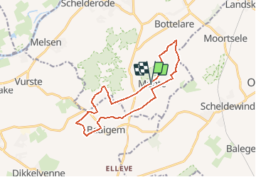
Asselkouter trail

Jan Pieters
User

Length
12.5 km

Max alt
52 m

Uphill gradient
96 m
Km-Effort
13.8 km

Min alt
18 m

Downhill gradient
95 m
Boucle
Yes
Creation date :
2020-09-20 10:32:16.053
Updated on :
2020-09-21 18:34:17.567
3h00
Difficulty : Easy

FREE GPS app for hiking
 SityTrail
IGN / Geographical institutes
SityTrail Plus
The world is yours!
About
Trail Trail of 12.5 km to be discovered at Flanders, East Flanders, Merelbeke. This trail is proposed by Jan Pieters.
Description
Nice trail in a very nice environment.
Pity of to much concrete roads.
Starting point 'Munte' is a pretty and cosy village.
Positioning
Country:
Belgium
Region :
Flanders
Department/Province :
East Flanders
Municipality :
Merelbeke
Location:
Munte
Start:(Dec)
Start:(UTM)
552281 ; 5643965 (31U) N.
Comments