


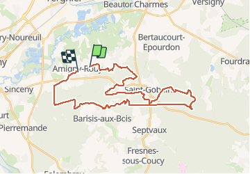
amigny rouy

jojo02
User

Length
34 km

Max alt
211 m

Uphill gradient
582 m
Km-Effort
42 km

Min alt
51 m

Downhill gradient
570 m
Boucle
No
Creation date :
2020-09-20 07:27:27.476
Updated on :
2020-09-20 10:40:40.165
2h50
Difficulty : Very easy

FREE GPS app for hiking
 SityTrail
IGN / Geographical institutes
SityTrail Plus
The world is yours!
About
Trail Mountain bike of 34 km to be discovered at Hauts-de-France, Aisne, Amigny-Rouy. This trail is proposed by jojo02.
Positioning
Country:
France
Region :
Hauts-de-France
Department/Province :
Aisne
Municipality :
Amigny-Rouy
Location:
Unknown
Start:(Dec)
Start:(UTM)
522961 ; 5495435 (31U) N.
Comments