


Soultzeren_Boden_Soultzersmatt

lemuid
User
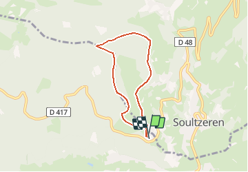

Length
5.6 km

Max alt
970 m

Uphill gradient
287 m
Km-Effort
9.4 km

Min alt
695 m

Downhill gradient
288 m
Boucle
Yes
Creation date :
2020-09-20 14:45:39.669
Updated on :
2020-09-20 14:56:14.296
1h55
Difficulty : Medium

FREE GPS app for hiking
 SityTrail
IGN / Geographical institutes
SityTrail Plus
The world is yours!
About
Trail Walking of 5.6 km to be discovered at Grand Est, Haut-Rhin, Stosswihr. This trail is proposed by lemuid.
Photos


Positioning
Country:
France
Region :
Grand Est
Department/Province :
Haut-Rhin
Municipality :
Stosswihr
Location:
Unknown
Start:(Dec)
Start:(UTM)
357751 ; 5324776 (32U) N.
Comments