


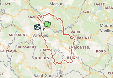
Arrènes Tour

csy95
User

Length
14.6 km

Max alt
538 m

Uphill gradient
332 m
Km-Effort
19 km

Min alt
376 m

Downhill gradient
338 m
Boucle
No
Creation date :
2020-09-20 12:07:43.43
Updated on :
2020-09-20 15:16:39.431
3h08
Difficulty : Easy

FREE GPS app for hiking
 SityTrail
IGN / Geographical institutes
SityTrail Plus
The world is yours!
About
Trail Walking of 14.6 km to be discovered at New Aquitaine, Creuse, Arrènes. This trail is proposed by csy95.
Positioning
Country:
France
Region :
New Aquitaine
Department/Province :
Creuse
Municipality :
Arrènes
Location:
Unknown
Start:(Dec)
Start:(UTM)
389585 ; 5103264 (31T) N.
Comments