


Errent bois Brûlé

David Degehet
User
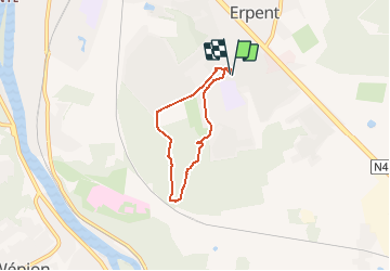

Length
4.3 km

Max alt
204 m

Uphill gradient
68 m
Km-Effort
5.2 km

Min alt
155 m

Downhill gradient
70 m
Boucle
Yes
Creation date :
2020-09-20 15:12:13.118
Updated on :
2020-09-20 18:25:51.008
1h02
Difficulty : Very easy

FREE GPS app for hiking
 SityTrail
IGN / Geographical institutes
SityTrail Plus
The world is yours!
About
Trail Walking of 4.3 km to be discovered at Wallonia, Namur, Namur. This trail is proposed by David Degehet.
Description
Facile, agréable... à la portée de tous
Positioning
Country:
Belgium
Region :
Wallonia
Department/Province :
Namur
Municipality :
Namur
Location:
Erpent
Start:(Dec)
Start:(UTM)
634695 ; 5589373 (31U) N.
Comments