


Rando Forges les Eaux 31 aout 2025 Matin

maillebreze
User
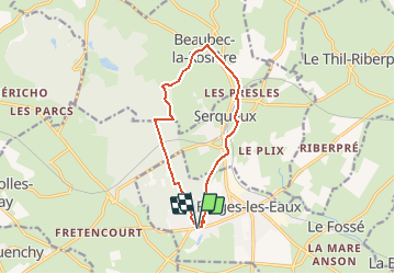

Length
10.7 km

Max alt
181 m

Uphill gradient
121 m
Km-Effort
12.4 km

Min alt
134 m

Downhill gradient
121 m
Boucle
Yes
Creation date :
2020-09-21 11:45:28.42
Updated on :
2025-07-15 16:32:41.404
2h48
Difficulty : Difficult

FREE GPS app for hiking
 SityTrail
IGN / Geographical institutes
SityTrail Plus
The world is yours!
About
Trail Walking of 10.7 km to be discovered at Normandy, Seine-Maritime, Forges-les-Eaux. This trail is proposed by maillebreze.
Positioning
Country:
France
Region :
Normandy
Department/Province :
Seine-Maritime
Municipality :
Forges-les-Eaux
Location:
Forges-les-Eaux
Start:(Dec)
Start:(UTM)
393768 ; 5496168 (31U) N.
Comments