


Senlis

petergole
User

Length
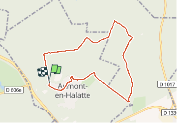
8.6 km

Max alt
148 m

Uphill gradient
113 m
Km-Effort
10.1 km

Min alt
88 m

Downhill gradient
123 m
Boucle
Yes
Creation date :
2020-09-19 15:38:40.0
Updated on :
2020-09-21 13:30:46.994
2h06
Difficulty : Unknown

FREE GPS app for hiking
 SityTrail
IGN / Geographical institutes
SityTrail Plus
The world is yours!
About
Trail Walking of 8.6 km to be discovered at Hauts-de-France, Oise, Aumont-en-Halatte. This trail is proposed by petergole.
Positioning
Country:
France
Region :
Hauts-de-France
Department/Province :
Oise
Municipality :
Aumont-en-Halatte
Location:
Unknown
Start:(Dec)
Start:(UTM)
466950 ; 5453299 (31U) N.
Comments