


balade viols le fort

Jp Lauron
User
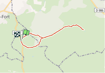

Length
7.3 km

Max alt
252 m

Uphill gradient
79 m
Km-Effort
8.4 km

Min alt
206 m

Downhill gradient
86 m
Boucle
Yes
Creation date :
2020-09-21 13:19:41.058
Updated on :
2020-09-21 15:38:34.586
2h18
Difficulty : Very easy

FREE GPS app for hiking
 SityTrail
IGN / Geographical institutes
SityTrail Plus
The world is yours!
About
Trail Walking of 7.3 km to be discovered at Occitania, Hérault, Argelliers. This trail is proposed by Jp Lauron.
Positioning
Country:
France
Region :
Occitania
Department/Province :
Hérault
Municipality :
Argelliers
Location:
Unknown
Start:(Dec)
Start:(UTM)
557883 ; 4842471 (31T) N.
Comments