


Aigueze bouboule

brandy
User
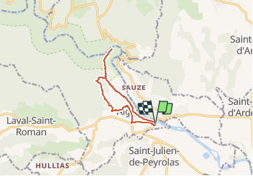

Length
9.9 km

Max alt
257 m

Uphill gradient
361 m
Km-Effort
14.7 km

Min alt
53 m

Downhill gradient
365 m
Boucle
Yes
Creation date :
2020-09-21 17:50:03.949
Updated on :
2020-09-21 17:51:41.338
3h04
Difficulty : Difficult

FREE GPS app for hiking
 SityTrail
IGN / Geographical institutes
SityTrail Plus
The world is yours!
About
Trail Walking of 9.9 km to be discovered at Occitania, Gard, Aiguèze. This trail is proposed by brandy.
Positioning
Country:
France
Region :
Occitania
Department/Province :
Gard
Municipality :
Aiguèze
Location:
Unknown
Start:(Dec)
Start:(UTM)
624949 ; 4906287 (31T) N.
Comments