


moncontour

ballay
User

Length
20 km

Max alt
345 m

Uphill gradient
419 m
Km-Effort
26 km

Min alt
111 m

Downhill gradient
450 m
Boucle
No
Creation date :
2020-09-22 08:15:12.038
Updated on :
2020-09-22 14:28:24.816
6h11
Difficulty : Easy

FREE GPS app for hiking
 SityTrail
IGN / Geographical institutes
SityTrail Plus
The world is yours!
About
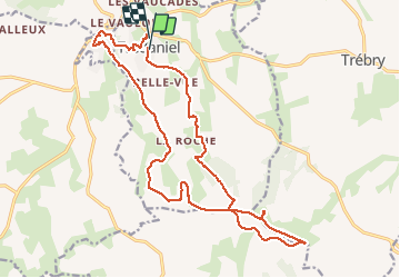
Trail Walking of 20 km to be discovered at Brittany, Côtes-d'Armor, Trédaniel. This trail is proposed by ballay.
Description
tredaniel
Positioning
Country:
France
Region :
Brittany
Department/Province :
Côtes-d'Armor
Municipality :
Trédaniel
Location:
Unknown
Start:(Dec)
Start:(UTM)
528227 ; 5356134 (30U) N.
Comments