


randogps7-235

raab
User

Length
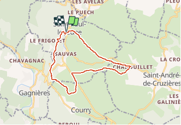
14.6 km

Max alt
440 m

Uphill gradient
360 m
Km-Effort
19.4 km

Min alt
165 m

Downhill gradient
361 m
Boucle
Yes
Creation date :
2020-09-22 15:32:32.629
Updated on :
2020-09-22 15:33:17.929
--
Difficulty : Easy

FREE GPS app for hiking
 SityTrail
IGN / Geographical institutes
SityTrail Plus
The world is yours!
About
Trail On foot of 14.6 km to be discovered at Auvergne-Rhône-Alpes, Ardèche, Saint-Paul-le-Jeune. This trail is proposed by raab.
Positioning
Country:
France
Region :
Auvergne-Rhône-Alpes
Department/Province :
Ardèche
Municipality :
Saint-Paul-le-Jeune
Location:
Unknown
Start:(Dec)
Start:(UTM)
591821 ; 4910002 (31T) N.
Comments