


track

raab
User
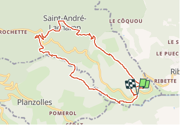

Length
10.9 km

Max alt
704 m

Uphill gradient
502 m
Km-Effort
17.7 km

Min alt
250 m

Downhill gradient
516 m
Boucle
Yes
Creation date :
2020-09-22 15:35:03.11
Updated on :
2020-09-22 15:35:57.342
--
Difficulty : Medium

FREE GPS app for hiking
 SityTrail
IGN / Geographical institutes
SityTrail Plus
The world is yours!
About
Trail On foot of 10.9 km to be discovered at Auvergne-Rhône-Alpes, Ardèche, Saint-André-Lachamp. This trail is proposed by raab.
Positioning
Country:
France
Region :
Auvergne-Rhône-Alpes
Department/Province :
Ardèche
Municipality :
Saint-André-Lachamp
Location:
Unknown
Start:(Dec)
Start:(UTM)
594599 ; 4926703 (31T) N.
Comments