


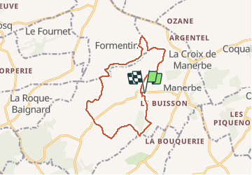
Manerbe

Eve - Line
User

Length
13.2 km

Max alt
157 m

Uphill gradient
243 m
Km-Effort
16.4 km

Min alt
67 m

Downhill gradient
243 m
Boucle
Yes
Creation date :
2020-09-24 07:05:33.833
Updated on :
2020-09-24 09:51:08.395
2h44
Difficulty : Medium

FREE GPS app for hiking
 SityTrail
IGN / Geographical institutes
SityTrail Plus
The world is yours!
About
Trail Walking of 13.2 km to be discovered at Normandy, Calvados, Manerbe. This trail is proposed by Eve - Line.
Photos


30 photos in total. Please click on a photo to see them all in the gallery.
Positioning
Country:
France
Region :
Normandy
Department/Province :
Calvados
Municipality :
Manerbe
Location:
Unknown
Start:(Dec)
Start:(UTM)
292769 ; 5451702 (31U) N.
Comments