


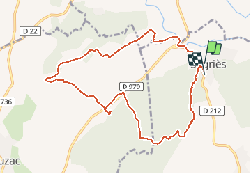
Sagries

René Strouwen
User

Length
10.8 km

Max alt
164 m

Uphill gradient
201 m
Km-Effort
13.5 km

Min alt
61 m

Downhill gradient
196 m
Boucle
No
Creation date :
2020-09-24 11:29:55.01
Updated on :
2020-09-24 14:15:56.504
2h44
Difficulty : Easy

FREE GPS app for hiking
 SityTrail
IGN / Geographical institutes
SityTrail Plus
The world is yours!
About
Trail Walking of 10.8 km to be discovered at Occitania, Gard, Sanilhac-Sagriès. This trail is proposed by René Strouwen.
Positioning
Country:
France
Region :
Occitania
Department/Province :
Gard
Municipality :
Sanilhac-Sagriès
Location:
Unknown
Start:(Dec)
Start:(UTM)
613746 ; 4870538 (31T) N.
Comments