


croc madonne Utelle

sylvainstaels
User
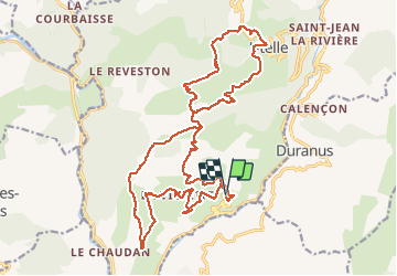

Length
26 km

Max alt
1188 m

Uphill gradient
1408 m
Km-Effort
45 km

Min alt
321 m

Downhill gradient
1409 m
Boucle
Yes
Creation date :
2020-09-26 05:38:01.578
Updated on :
2020-09-26 05:38:29.167
2h45
Difficulty : Difficult

FREE GPS app for hiking
 SityTrail
IGN / Geographical institutes
SityTrail Plus
The world is yours!
About
Trail Mountain bike of 26 km to be discovered at Provence-Alpes-Côte d'Azur, Maritime Alps, Utelle. This trail is proposed by sylvainstaels.
Positioning
Country:
France
Region :
Provence-Alpes-Côte d'Azur
Department/Province :
Maritime Alps
Municipality :
Utelle
Location:
Unknown
Start:(Dec)
Start:(UTM)
358188 ; 4860486 (32T) N.
Comments