


2020-09-27_08h35m03_hotton_itin_raire_noir_balis___39_92_km_

Chanchan63
User
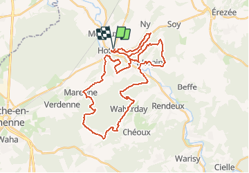

Length
40 km

Max alt
409 m

Uphill gradient
986 m
Km-Effort
53 km

Min alt
174 m

Downhill gradient
986 m
Boucle
Yes
Creation date :
2020-09-27 06:35:05.853
Updated on :
2020-09-27 18:35:21.461
11h17
Difficulty : Very difficult

FREE GPS app for hiking
 SityTrail
IGN / Geographical institutes
SityTrail Plus
The world is yours!
About
Trail Walking of 40 km to be discovered at Wallonia, Luxembourg, Hotton. This trail is proposed by Chanchan63.
Description
Très belle balade ,très beaux points de vues ,tout au long de la rando.
Positioning
Country:
Belgium
Region :
Wallonia
Department/Province :
Luxembourg
Municipality :
Hotton
Location:
Hotton
Start:(Dec)
Start:(UTM)
674587 ; 5571466 (31U) N.
Comments