


tour donezan

babouille
User
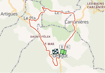

Length
8.8 km

Max alt
1232 m

Uphill gradient
245 m
Km-Effort
12.1 km

Min alt
1045 m

Downhill gradient
245 m
Boucle
Yes
Creation date :
2020-09-27 07:31:27.453
Updated on :
2020-09-27 08:47:35.765
1h15
Difficulty : Very easy

FREE GPS app for hiking
 SityTrail
IGN / Geographical institutes
SityTrail Plus
The world is yours!
About
Trail Running of 8.8 km to be discovered at Occitania, Ariège, Quérigut. This trail is proposed by babouille.
Positioning
Country:
France
Region :
Occitania
Department/Province :
Ariège
Municipality :
Quérigut
Location:
Unknown
Start:(Dec)
Start:(UTM)
426155 ; 4727710 (31T) N.
Comments