


Fagnes 2020 validée

JLDECK
User
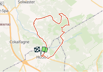

Length
14.9 km

Max alt
601 m

Uphill gradient
259 m
Km-Effort
18.4 km

Min alt
460 m

Downhill gradient
256 m
Boucle
Yes
Creation date :
2020-09-27 08:10:55.816
Updated on :
2020-09-27 12:50:21.232
4h10
Difficulty : Medium

FREE GPS app for hiking
 SityTrail
IGN / Geographical institutes
SityTrail Plus
The world is yours!
About
Trail Walking of 14.9 km to be discovered at Wallonia, Liège, Stavelot. This trail is proposed by JLDECK.
Positioning
Country:
Belgium
Region :
Wallonia
Department/Province :
Liège
Municipality :
Stavelot
Location:
Francorchamps
Start:(Dec)
Start:(UTM)
711752 ; 5596570 (31U) N.
Comments