


Stavelot - Rocher de Falize - Coo clemdpp

clemsdpp
User
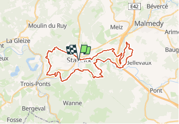

Length
35 km

Max alt
510 m

Uphill gradient
1052 m
Km-Effort
49 km

Min alt
252 m

Downhill gradient
1047 m
Boucle
Yes
Creation date :
2020-09-27 13:38:40.159
Updated on :
2020-11-10 13:13:09.074
11h10
Difficulty : Very difficult

FREE GPS app for hiking
 SityTrail
IGN / Geographical institutes
SityTrail Plus
The world is yours!
About
Trail Walking of 35 km to be discovered at Wallonia, Liège, Stavelot. This trail is proposed by clemsdpp.
Positioning
Country:
Belgium
Region :
Wallonia
Department/Province :
Liège
Municipality :
Stavelot
Location:
Stavelot
Start:(Dec)
Start:(UTM)
708311 ; 5586442 (31U) N.
Comments