


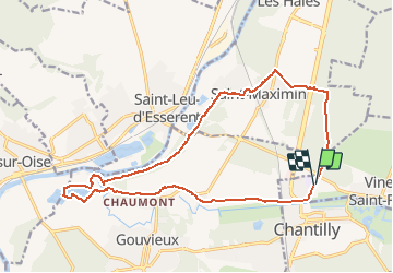
Bois de la Coharde - Gouvieux - Camp César

philberard95
User

Length
17.1 km

Max alt
83 m

Uphill gradient
197 m
Km-Effort
19.8 km

Min alt
24 m

Downhill gradient
196 m
Boucle
Yes
Creation date :
2020-09-28 09:22:35.468
Updated on :
2020-09-28 09:23:30.058
4h20
Difficulty : Very difficult

FREE GPS app for hiking
 SityTrail
IGN / Geographical institutes
SityTrail Plus
The world is yours!
About
Trail Walking of 17.1 km to be discovered at Hauts-de-France, Oise, Vineuil-Saint-Firmin. This trail is proposed by philberard95.
Positioning
Country:
France
Region :
Hauts-de-France
Department/Province :
Oise
Municipality :
Vineuil-Saint-Firmin
Location:
Unknown
Start:(Dec)
Start:(UTM)
461280 ; 5449999 (31U) N.
Comments