


Cerniébaud 24 sept 2020 CAF

TRIMAILLE
User
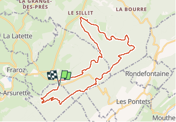

Length
21 km

Max alt
1228 m

Uphill gradient
580 m
Km-Effort
29 km

Min alt
922 m

Downhill gradient
585 m
Boucle
Yes
Creation date :
2020-09-30 12:11:36.215
Updated on :
2020-10-01 15:49:55.17
6h09
Difficulty : Difficult

FREE GPS app for hiking
 SityTrail
IGN / Geographical institutes
SityTrail Plus
The world is yours!
About
Trail Walking of 21 km to be discovered at Bourgogne-Franche-Comté, Jura, Fraroz. This trail is proposed by TRIMAILLE.
Description
Belvédères et un joli lapiaz
IBP 65
Photos


Positioning
Country:
France
Region :
Bourgogne-Franche-Comté
Department/Province :
Jura
Municipality :
Fraroz
Location:
Unknown
Start:(Dec)
Start:(UTM)
279928 ; 5178849 (32T) N.
Comments