


chaintré

janussity
User
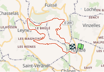

Length
9.6 km

Max alt
412 m

Uphill gradient
256 m
Km-Effort
13 km

Min alt
244 m

Downhill gradient
255 m
Boucle
Yes
Creation date :
2020-09-30 13:42:04.999
Updated on :
2020-09-30 16:18:56.782
2h09
Difficulty : Easy

FREE GPS app for hiking
 SityTrail
IGN / Geographical institutes
SityTrail Plus
The world is yours!
About
Trail Walking of 9.6 km to be discovered at Bourgogne-Franche-Comté, Saône-et-Loire, Chaintré. This trail is proposed by janussity.
Description
on beautemos
Photos


Positioning
Country:
France
Region :
Bourgogne-Franche-Comté
Department/Province :
Saône-et-Loire
Municipality :
Chaintré
Location:
Unknown
Start:(Dec)
Start:(UTM)
635602 ; 5124453 (31T) N.
Comments