


col de porte - charmant som

trailer38
User
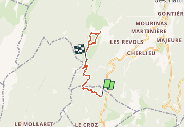

Length
9.4 km

Max alt
1857 m

Uphill gradient
575 m
Km-Effort
16.1 km

Min alt
1326 m

Downhill gradient
274 m
Boucle
No
Creation date :
2020-09-30 14:05:28.443
Updated on :
2020-09-30 19:04:45.217
2h28
Difficulty : Very easy

FREE GPS app for hiking
 SityTrail
IGN / Geographical institutes
SityTrail Plus
The world is yours!
About
Trail Trail of 9.4 km to be discovered at Auvergne-Rhône-Alpes, Isère, Sarcenas. This trail is proposed by trailer38.
Positioning
Country:
France
Region :
Auvergne-Rhône-Alpes
Department/Province :
Isère
Municipality :
Sarcenas
Location:
Unknown
Start:(Dec)
Start:(UTM)
716793 ; 5019408 (31T) N.
Comments